Westwood Reach
2021
Harvard University Graduate School of Design
Instructor:Yun Fu / Peter G. Rowe
Team: Saad Boujane, Grant Fahlgren
Location: Westwood, Massachussetts
Area: 3.75 km²
![]()
![]()
![]()
![]()
Instructor:Yun Fu / Peter G. Rowe
Team: Saad Boujane, Grant Fahlgren
Location: Westwood, Massachussetts
Area: 3.75 km²

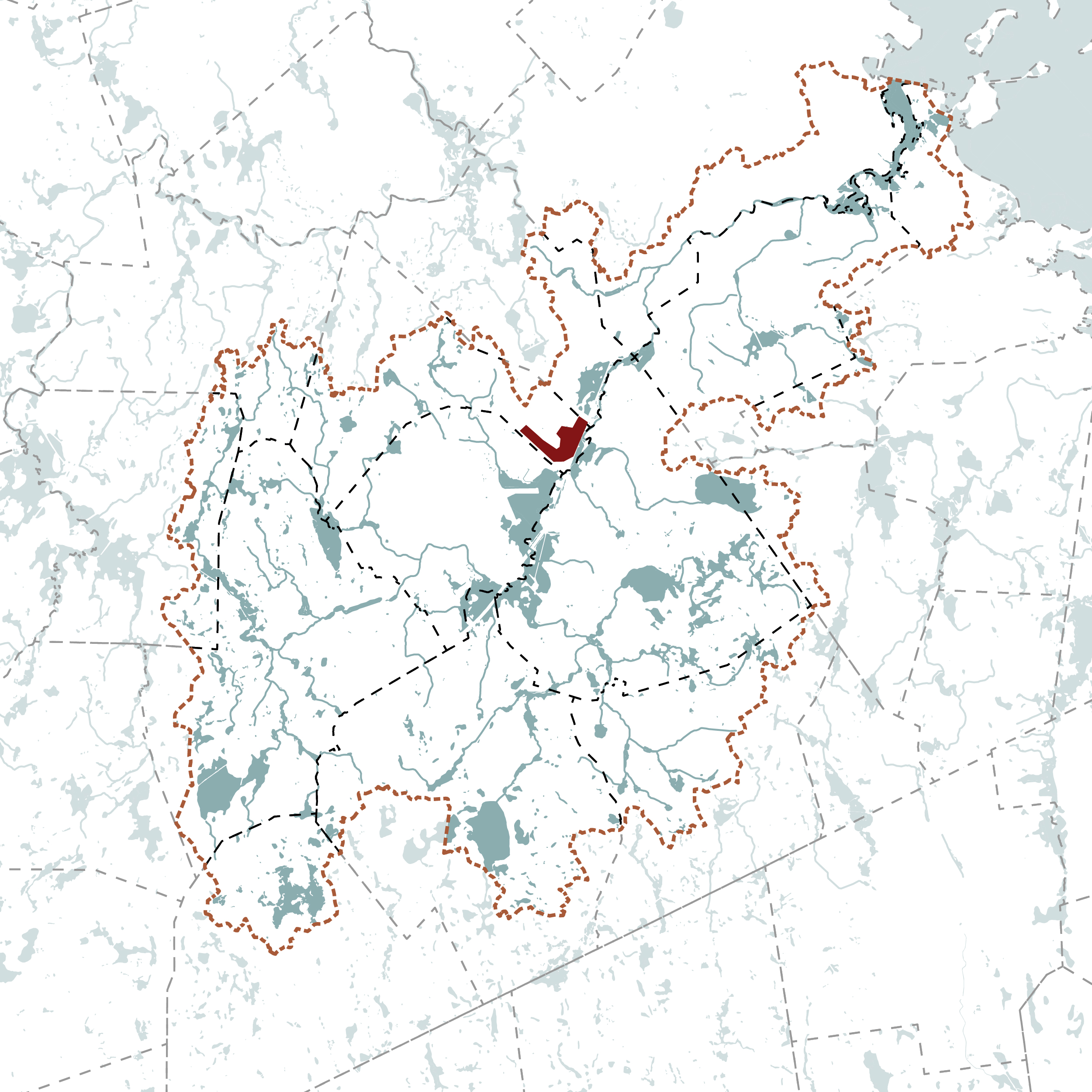

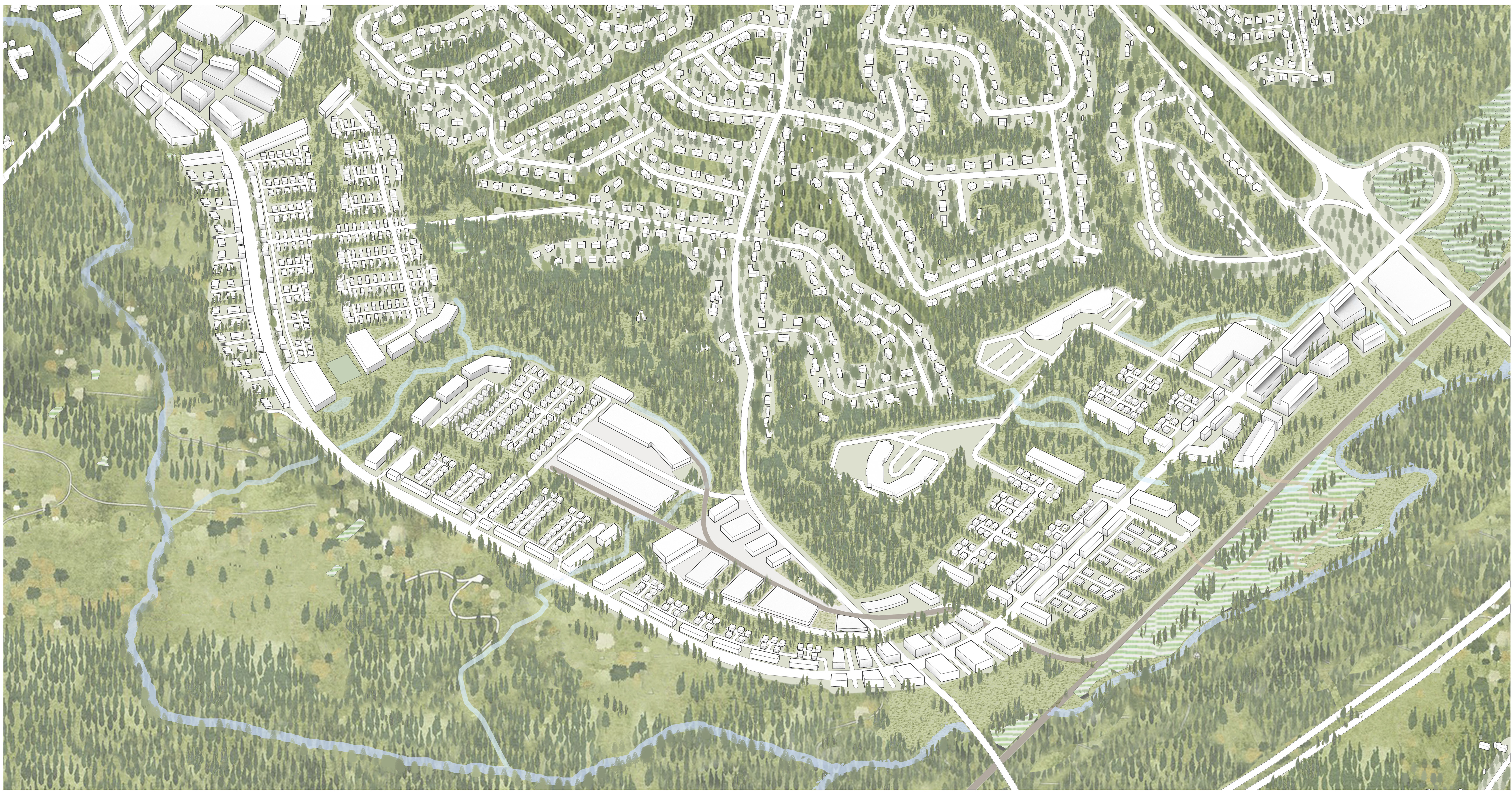
Westwood Reach examines the Route 128/University Park Station district in Westwood, MA, an urban peripheral area in flux. Like many suburbs in the United States, development in Westwood reached its peak in the 1970s and has since been in a state of stasis, albeit a relatively prosperous one in this case. However, as current thinking on urban design shifts from a myopic focus on the city center to the broader urban region and hinterland, there has been a renewed interest in the developmental potential of places on the urban periphery.
Westwood is a well-connected suburb in the Boston region, located at the intersection of two major highways: the I-128, the major ring road around Boston, and the I-93, the main route southwards. It is a transit hub, with direct Amtrak Rail connections to Boston and New York via the high-speed Acela train service, and MBTA commuter rail service to Boston South Station. Next door is Norwood Airport, the base of a pilot school, and a hub for chartered flights to Boston. The Route 128/University Park Station was built as one of the first park-and-ride facilities in the United States. Despite being surrounded by relatively bland parking facilities, business parks, and shopping malls, Westwood presents an attractive combination of easy commute, excellent schools, and quiet neighborhoods for the suburbanites, resulting in its persistently high property prices.
However, given the uncertain future of suburbs amidst long term demographic shifts away from the nuclear family, and broader concerns for social, economic and environmental sustainability, it would be pertinent for Westwood to explore new models of development that could expand its appeal to a wider range of people and programs. An obvious locus for this exploration is the area around the Route 128 Station, which had previously been conceived as a relatively autonomous transportation hub, disconnected from the neighboring towns, residential areas, and natural systems. In this context, students may assume the role of an urban designer appointed by the city of Westwood to propose a program and plan for future development in the area. The overall development should have a maximum FAR of 0.4 across the site or approximately 300,000m2 of useable floor area.
![]()
![]()
![]()
The site at Westwood foregrounds several issues for consideration. First, given the car-dominated model of suburban development, access to modes of transportation, particularly in the so-called last-mile,’ will be a critical issue in facilitating more diverse lifestyles, programs, and demography. Second, in the lower-density suburban context, the presence and importance of buildings recede, and it becomes critical and necessary to think of landscape as urban form - the shift presents the urban designer with a new repertoire of elements to consider and deploy. Third, while much of the infrastructure in the area is now somewhat dated, both in terms of its physical condition and function, the immense sunken costs make it impractical to rebuild anew. How might the existing infrastructure be retrofitted and reprogrammed to facilitate current and future needs? Fourth, development in the urban periphery will inevitably need to contend with general critiques of the suburban model of development, chief amongst which is the perceived monotony of experience and the uniformity of program and population. How can development in the suburbs facilitate senses of communities and places, in the plural, and accommodate the despecialization of programs over time?
![]()
![]()
![]()
![]()
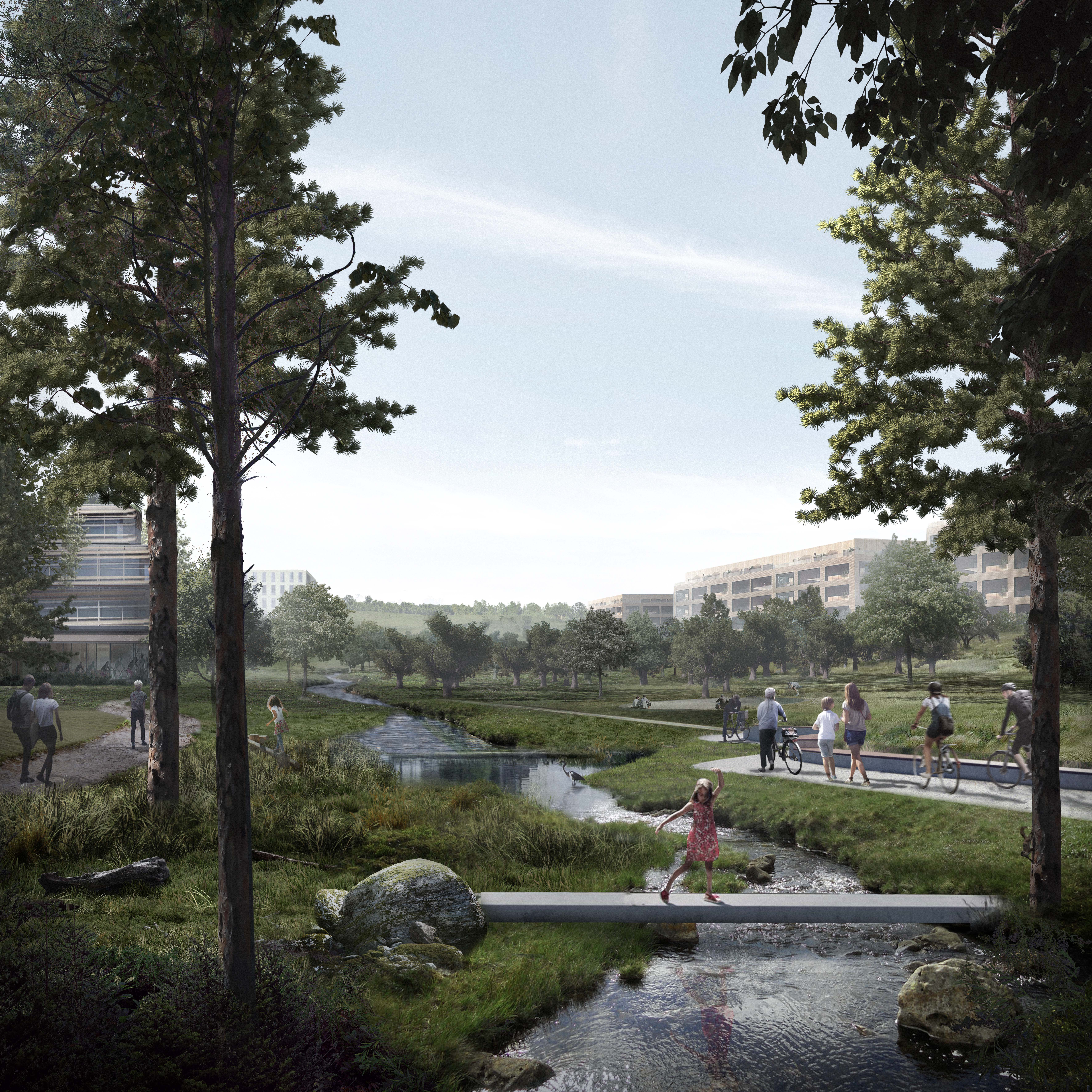
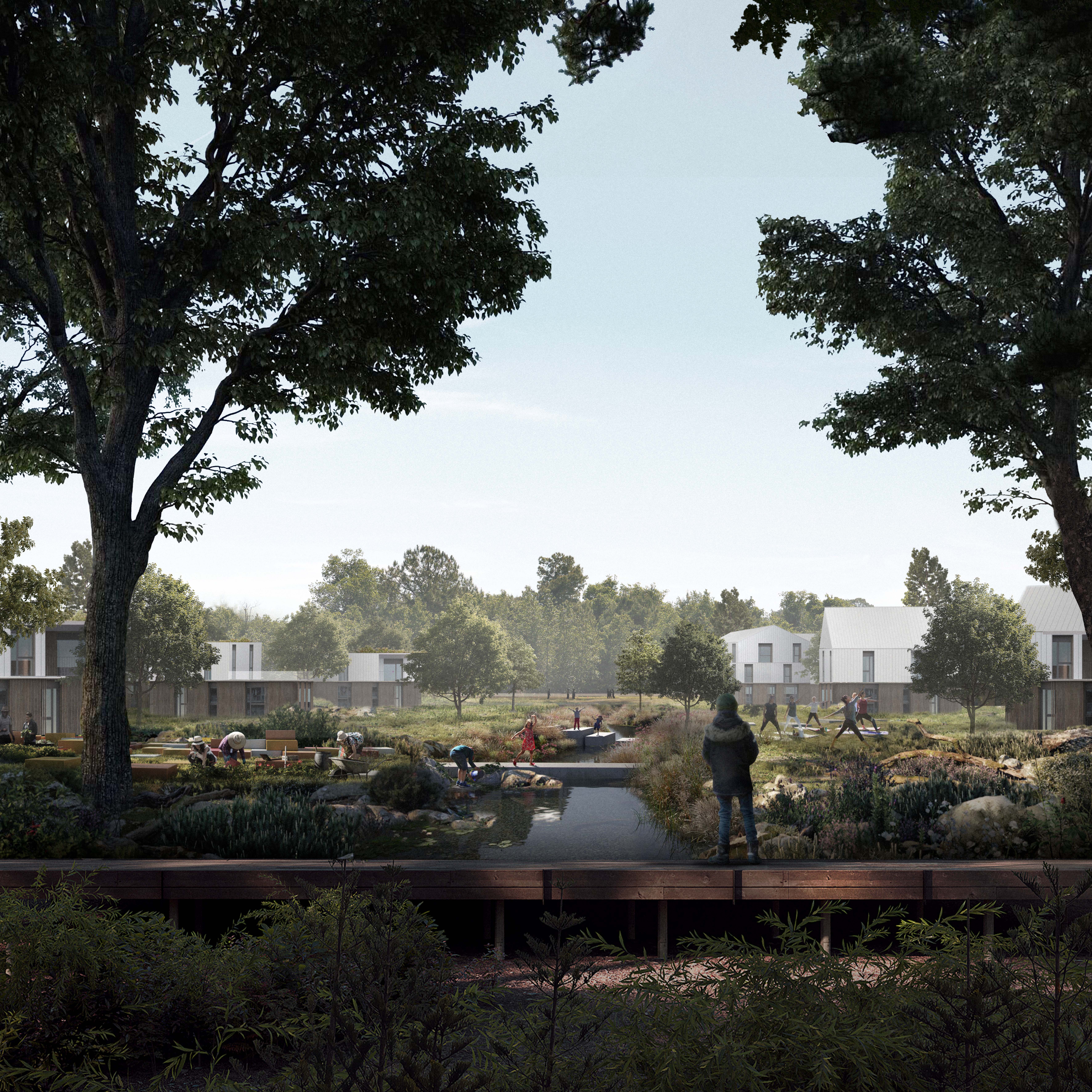
As the effects of climate change are increasing the intensity of storms and lengthening periods of drought, this shift is exacerbated by the decoupling of the urban hydrologic systems from the geomorphology that shapes and is shaped by the flows of water. Westwood Reach is a relational response that reorients this community at Boston’s urban periphery toward the hydrological and ecological systems that make it unique. Through its urban form, hydrologic flows are shaped by interventions in the public realm that amplify ecological systems, offering opportunities for engagement by residents while simultaneously improving these systems resilience in the face of climate change.
![]()
![]()
![]()
![]()
![]()
![]()
![]()
![]()
Westwood is a well-connected suburb in the Boston region, located at the intersection of two major highways: the I-128, the major ring road around Boston, and the I-93, the main route southwards. It is a transit hub, with direct Amtrak Rail connections to Boston and New York via the high-speed Acela train service, and MBTA commuter rail service to Boston South Station. Next door is Norwood Airport, the base of a pilot school, and a hub for chartered flights to Boston. The Route 128/University Park Station was built as one of the first park-and-ride facilities in the United States. Despite being surrounded by relatively bland parking facilities, business parks, and shopping malls, Westwood presents an attractive combination of easy commute, excellent schools, and quiet neighborhoods for the suburbanites, resulting in its persistently high property prices.
However, given the uncertain future of suburbs amidst long term demographic shifts away from the nuclear family, and broader concerns for social, economic and environmental sustainability, it would be pertinent for Westwood to explore new models of development that could expand its appeal to a wider range of people and programs. An obvious locus for this exploration is the area around the Route 128 Station, which had previously been conceived as a relatively autonomous transportation hub, disconnected from the neighboring towns, residential areas, and natural systems. In this context, students may assume the role of an urban designer appointed by the city of Westwood to propose a program and plan for future development in the area. The overall development should have a maximum FAR of 0.4 across the site or approximately 300,000m2 of useable floor area.


The site at Westwood foregrounds several issues for consideration. First, given the car-dominated model of suburban development, access to modes of transportation, particularly in the so-called last-mile,’ will be a critical issue in facilitating more diverse lifestyles, programs, and demography. Second, in the lower-density suburban context, the presence and importance of buildings recede, and it becomes critical and necessary to think of landscape as urban form - the shift presents the urban designer with a new repertoire of elements to consider and deploy. Third, while much of the infrastructure in the area is now somewhat dated, both in terms of its physical condition and function, the immense sunken costs make it impractical to rebuild anew. How might the existing infrastructure be retrofitted and reprogrammed to facilitate current and future needs? Fourth, development in the urban periphery will inevitably need to contend with general critiques of the suburban model of development, chief amongst which is the perceived monotony of experience and the uniformity of program and population. How can development in the suburbs facilitate senses of communities and places, in the plural, and accommodate the despecialization of programs over time?


As the effects of climate change are increasing the intensity of storms and lengthening periods of drought, this shift is exacerbated by the decoupling of the urban hydrologic systems from the geomorphology that shapes and is shaped by the flows of water. Westwood Reach is a relational response that reorients this community at Boston’s urban periphery toward the hydrological and ecological systems that make it unique. Through its urban form, hydrologic flows are shaped by interventions in the public realm that amplify ecological systems, offering opportunities for engagement by residents while simultaneously improving these systems resilience in the face of climate change.